Bush Explorers Encyclopaedia
Name:
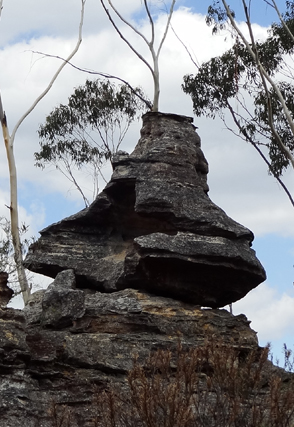
Tagine Point
Description:
Is located 2.6km south east of Birds Rock Trig Station. Michael Keats recorded on 13th March 2013," Looking at the last pagoda, a residual erosion piece, has reminded us of an oversize Moroccan tagine or cooking pot. It was so big, two of us could sit in it - great for pictures. This strange piece also had an irregular pair of narrow horizontal slot windows that could be used as picture frames. I have named this amazing place Tagine Point."
Maps:
- Cullen Bullen
Grid Reference:
- 404 068
Location:
Newnes State Forest
Status:
Threatened
Related Names:
Read More In:
Walks:
- GOS6.28: Silkpod Point and Silkpod Gorge
- GOS6.29: Wild Gorge and Pinch Point Circle
- GOS6.30: Convolution Creek and Tagine Point
Photos: