Bush Explorers Encyclopaedia
Name:
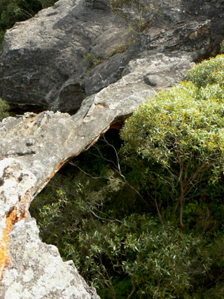
Clarence Arch
Description:
Is located 450m south west of the intersection of Donald Road and Ray Crescent, Clarence. This arch is about 15m high, 14m long and 1.5m wide. It is easy to walk on and off at the northern end but the southern end involves a pagoda climb. The southern end also is undercut with a very pleasant, ochre coloured, curved semi cave. This arch and the area below it came into prominence during the construction of the Main Western Line in the early 1900s.
Maps:
- Lithgow
Grid Reference:
- 414 913
Location:
Status:
Related Names:
Read More In:
Walks:
- GOS7.18: Clarence Arch
- GOS7.19: Blacksmith Cave
Photos: