Bush Explorers Encyclopaedia
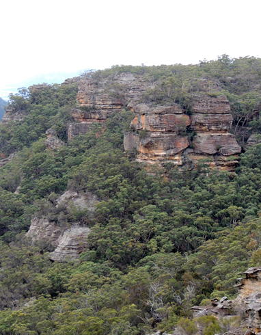
This double headed bluff overlooks the headwaters of Red Rock Creek, 2.2km south of Mount Harvey. Shown on the map Parish of Wolgan, 1st edition, September 1884. The parish map shows the name refers to the total bluff that looks directly down Red Rock Creek between Point March and Mount Harvey.
It appears that the name Cornell is misspelled and that the location was possibly named after John Connell (1851-1889). The Australian Town and Country Journal 1st September 1883, p. 23. SMH 17th August 1883, p. 6. Evening News 17th August 1883, p. 2. Record that a property of 640 acres shared by John Connell, Peter Wallace and James Loneragan as a Mineral Lease, that good quality Kerosene Shale was discovered. This area was in the vicinity of Ben Bullen Range and described as, “7 miles from Capertee 4 miles from the railway”. In 1888 John Connell also made another discovery of kerosene shale in the Marrangaroo Range, 6 miles from Lithgow Ref: SMH 17th July 1888, p. 8.
Other names that were misspelled include Collett Gap, should be Collitt and Mount Horne which is Mount Horn.
- Ben Bullen
- 350 216
- GOS2.01: Mount Harvey and Mount Dawson Pass
- GOS2.02: Mount Dawson and Gindantherie Pinnacle