Bush Explorers Encyclopaedia
Name:
Island Mountain
Description:
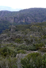
Is not so much a mountain but rather an elevated area bounded on three sides, west, north and east, by a huge loop of the Wolgan River. The southern side is Deanes Creek. This proscribed area is about 24sqkm. The Sydney Morning Herald, 10th January 1906, p. 7, ProposedTramway Route, records engineering difficulties in crossing Constance Gorge and Island Mountain. Other References; Tramway from Wolgan to Clarence. Survey Plan M12435. Surveyed by John Haydon Cardew, Licensed Surveyor, 13th December 1905.
Maps:
- Mount Morgan
Grid Reference:
- 465 245 central position
Location:
Wollemi National Park
Status:
Protected
Related Names:
Read More In:
Walks:
- GOS2.03: Point Anderson and Canobla Creek
- GOS2.10: The Pipeline Track
- GOS2.11: Mystery Mountain
- GOS2.13: Newnes - Wolgan River - Zobels Gully Triangle
- GOS2.14: The Cliffs of Mars
- GOS2.17: Constance Point
- GOS2.25: Island Mountain Traverse
- GOS2.26.1: The Totem Pole
Photos: