Bush Explorers Encyclopaedia
Name:
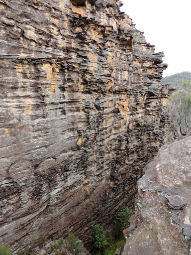
The Wall
Description:
Is a highly eroded almost vertical rock face within a narrow canyon that is accessed via Glowworm Tunnel Road and Waratah Ridge Road. It is located 3.3km south, south east of the junction of Waratah Ridge Road and Two Trees Road and 200m to the north of Bungleboori Creek. Named by David Blackwell, 19th September 2010.
Maps:
- Wollangambe
Grid Reference:
- 463 984
Location:
Newnes State Forest
Status:
Threatened
Related Names:
Read More In:
Walks:
- GOS1.23: The Eastern Extension of Mount Genowlan
- GOS2.01: Mount Harvey and Mount Dawson Pass
- GOS2.16: An unnamed tributary of Deanes Creek
- GOS3.16: Carne Creek Cliffs, Felt Fern Canyon and Pyramid Rocks
- GOS3.18: Above the Glowworm Tunnel
- GOS3.20: Unnamed tributary of Deanes Creek
- GOS4.11: Bungleboori Creek and the WWII Water Supply Dam
- GOS4.37: The Arch in Arch Canyon
- GOS5.02: Gaudis Walls
- GOS5.21: Long Swamp
- GOS6.02: Last Crusade Point and Holy Grail Ravine
- GOS6.08: Rockflower Ridge and Creek
- GOS6.17: Infinity Caves
- GOS6.25: Sinusoidal Ravine and cliffs above Carne Creek
- GOS6.29: Wild Gorge and Pinch Point Circle
- GOS7.06: Clerestory Spurs No. 4 to No. 7
- GOS7.12: Lost City and more
- GOS7.21: State Mine Gully and Hassans Walls
- GOS7.22: The Zig-Zag Railway and Ida Falls Creek
Photos: