Bush Explorers Encyclopaedia
Name:
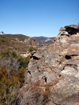
Mount Dawson *
Description:
Is a prominence on a mesa 5km south west of Newnes.To the east, are the tributaries of Capertee Creek, to the south, Barton Creek, and to the west, Red Rock Creek. Shown on the map Parish of Goollooinboin, 1884. Possibly named after T. J. Dawson, who purchased 4000ac from Sir John Jamison. Name recorded on the Survey Plan 224.1507, dated 1866, but sale was prior to this date. Another contender for this name is Jessie Dawson, who in 1874 purchased land fronting Coco Creek as well as Portion 6, Parish of Coco, County of Cook, in 1899. Ref: Survey Plan 2778.1496. The licensed surveyor for this plan was James Dawson.
Maps:
- Ben Bullen
Grid Reference:
- 377 240
Location:
Wollemi National Park
Status:
Protected
Related Names:
Read More In:
Walks:
- GOS1.06: Pantoneys Crown
- GOS1.09: Passes of East Genowlan Mountain
- GOS1.10: The Cliffs South East of Genowlan Mountain
- GOS1.21: Blackmans Crown and Platform Rock
- GOS2.01: Mount Harvey and Mount Dawson Pass
- GOS2.02: Mount Dawson and Gindantherie Pinnacle
- GOS2.06: The Wolgan - Capertee Divide
- GOS2.19: The Minotaur Lair
- GOS2.21: The cliffs of Koopartoo
- GOS2.22: The cliffs and ravines of Western Koopartoo
- GOS2.24: Traversing Pantoneys Crown
- GOS2.25: Island Mountain Traverse
- GOS2.27: Mount Dawson via Capertee Creek
- GOS3.01: Donkey Mountain 1
- GOS3.10: Carne Creek Cliffs, Nobles Canyon and the fissures
- GOS5.21: Long Swamp
- GOS6.26: Birds Rock Creek
Photos: